


rando Hiva Oa 10 km

jeanmarcMasson
User GUIDE
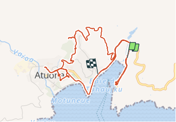

Length
11.7 km

Max alt
172 m

Uphill gradient
305 m
Km-Effort
15.7 km

Min alt
5 m

Downhill gradient
300 m
Boucle
No
Creation date :
2023-11-10 17:39:13.595
Updated on :
2023-11-10 23:37:51.797
2h30
Difficulty : Difficult

FREE GPS app for hiking
 SityTrail
IGN / Geographical institutes
SityTrail World
The world is yours!
About
Trail Walking of 11.7 km to be discovered at Unknown, Unknown, Hiva Oa. This trail is proposed by jeanmarcMasson.
Positioning
Country:
France
Region :
Unknown
Department/Province :
Unknown
Municipality :
Hiva Oa
Location:
Atuona
Start:(Dec)
Start:(UTM)
716192 ; 8915982 (7L) S.
Comments
Trails nearby